About County Westmeath
Info from Draft Westmeath County Development Plan 2021-2027 - download a full copy of the draft plan HERE
Located in the heart of Ireland, County Westmeath covers an area of 1,756 square kilometres and is historically known as the ‘Lake County’, rich in arts, culture, heritage and natural amenities. These many natural amenities include the Hill of Uisneach, the mythological and sacred centre of Ireland, the River Shannon and Lough Ree, adjacent to Athlone, the River Brosna, Lough Owel and Lough Ennell, adjacent to Mullingar, with Lough Derravaragh, Lough Lene and Lough Sheelin in the north of the County. In terms of national and international tourism promotion, Westmeath’s appeal is recognised and benefits from the dual promotion of Fáilte Ireland’s ‘Ancient East’ brand proposition to the east of the County and ‘Ireland’s Hidden Heartlands’ to the west.
Westmeath has an array of attractive towns and villages ranging from the thriving Regional Centre of Athlone, the County town of Mullingar, to the strong market towns of Moate and Kinnegad and the quaint and historical villages such as Multyfarnham, Glasson and Tyrrellspass.
The M4/N4 which traverses the County in a north-westerly direction offers the County ease of access to the greater Dublin area, with Dublin Airport and Dublin Port just one hour’s drive from Mullingar. The M6 from Kinnegad, through Athlone provides further connection to Galway and the West. The N52, an important national secondary route traversing the County, further connects the north east with the Munster region. Significant rail infrastructure enhances this connectivity, with the Dublin-Sligo railway line serving Mullingar and the Dublin-Westport/Dublin-Galway line serving Athlone. Westmeath is also home to a strategic section of the Galway to Dublin National Cycle Network (NCN.) Extending across the County from the Meath County Boundary along the existing Royal Canal Greenway to Mullingar before connecting to ‘The Old Rail Trail’ for 42km to the town of Athlone.
There are four electoral areas in the County, Mullingar, Kinnegad, Moate and Athlone which in turn form the Mullingar-Kinnegad and Athlone-Moate Municipal Districts through which many of the local services are delivered by the Council.

Business in Westmeath
The designation of Athlone as a Regional Growth Centre supported by the identification of Mullingar as a Key Town in the National Planning Framework has elevated Westmeath’s position in the Midlands region and represents a significant advancement for the County with a focus on improving local economies and quality of life to attract investment supported by sustainable communities. The inclusion of Athlone as regional driver will provide for increased employment and investment opportunities supported by the strong tourism assets identified throughout the County and targeted regeneration projects.
The Core Strategy (Chapter 3) identifies the population trends and targets for Westmeath together with the settlement hierarchy in accordance with the NPF and RSES.
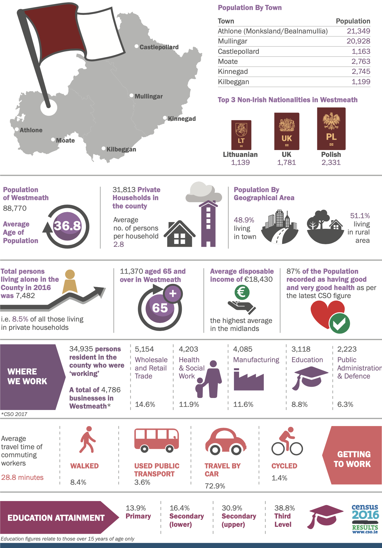
Census 2016 recorded a population of 88,770 in Westmeath consisting of 44,688 females and 44,082 males, an increase of 3% since the previous census in 2011. 48.9% (43,435 persons) of the County’s population were recorded as living in urban areas and 51.1% (45,335 persons) living in rural areas. During the period 2011-2016 the two main towns, Athlone and Mullingar, experienced a population increase of 5.9% (20,153 to 21,349) and 4.1% (20,103 to 20,928) respectively.
Population trends, economic trends and societal changes as outlined in the below infographic influence the decision-making process and service delivery planning. Having awareness and understanding of these societal changes is critical in determining future strategic objectives. As the main provider of local services, we must be aware of these changes and adopt strategies and plans to meet changing societal needs.
